Sunday 6 May 2007

Mapping parties

So what is it about mapping parties, that makes them so good for the towns, and so slow for wilderness?


This is the New Forest in southern England, after being covered by one mapping party per weekend for most of 2006. (slight exageration, but lots of people have visited this area to do mapping)

One thing to notice, is that in the city you have a frame of reference (the street layout) in which you can place things that you see. So even though you might never visit a particular feature, you can see where it is based on what roads are around it.

It's very difficult to do that for features out in farmland or open country. Even if you can see something (say, a copse) you can't put it on the map without knowing its exact position. Which means estimating distance and direction.

That's why countryside maps have the footpaths themselves, but never anything off the path. How would you know where to put it?

To solve this problem, we need a way that you can look out over a landscape, sketch (or photograph) important features that you can see, and then create an accurate map from that information. So what frameworks are available to help with this estimation?

Contours would be a start. Very few OSM map tools allow you to view the contours of an area when you're editing. But if they did... you'd be able to match your photos against the landscape, and place features in their correct places relative to hills and valleys.

Anyone want to put the technology together, so that we could test it with a snowdonia mapping party?

So what do we do to develop this countryside map?

So what do we do to develop this countryside map?

Let's start by going on a typical walk with an OpenStreetMap surveyor. Using a GPS to record where you walked, a notepad and camera to record what you see. After you get back and edit the area, you end up with something like this:


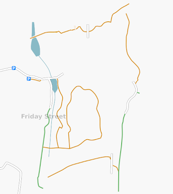
(actually that was two walks). It's not very impressive is it? Would you publish that, or use it when walking? For comparison, this is how the OS show that area.

(Google doesn't care of course - if you can't drive on it, they don't show it. So it's only OS and harveys to compete against)

Notice the stubs of road or path, where you see a route but don't follow it. You get a lot of those while walking, because it's actually quite difficult to follow every path in an efficient way.

There's a difference here between city and country. In the city, (a) you have bikes, which are about 5x as efficient as pedestrians for mapping, (b) are more likely to have good aerial photography available, and most importantly (c) the grid of streets is usable on its own as a complete map, without having to care about the features inbetween.

In the country, a map showing only rights-of-way isn't really good enough, as the image above shows. It doesn't give you any feel for the terrain, it doesn't show you what to expect, and if you get lost, the map is of no help because it doesn't show any points of interest.

So what can we do to improve it?

(1) Contours are good, although only NickW seems to be developing these at the moment, and only for a very small part of the country.

Maybe we should have a tileserver serving transparent contours for the whole country that can be overlaid on any map?

(2) Forests, woodlands, and lakes. I know we're starting to do these and they appear on the map, which is good, from aerial photos.

There doesn't seem to be any one project to systematically go through satellite and aerial photos of an area and mark visible features on the map. If some people sketched out these features for their local national park (in the same way as Dave Groom and others have done for Baghdad) that might give interesting results.

(3) More visible features. What does it take for hedgelines and lone trees to show-up in our maps? Can we mark ridges? Farms? Viewpoints? Gulleys, ledges, craters and other small -scale terrain features? Why can't we add arbitrary labels to the map, showing things like reservoirs, fords, steps, bike hire, drinking water taps and toilets, cafes, stiles, symbols for pubs which serve food -- let them all appear on the map as labels _while_ we debate what official tagging scheme and rendering icons to use for them.

We still can't even differentiate between a cornfield and a cowfield. "landuse=farm" for both of them. Without fixes like that, it's going to be difficult to plan a walk in OSM, or to correlate the printed map in your hand with the view you're looking at.

(p.s. it doesn't help that highway=footpath is completely invisible in OSM maps, and that nobody has converted them to the "new approved" tag scheme)

(4) Mapping parties. Subject for a different blog post I think, or perhaps one by NickW.

Ramblers == freeloaders?

So Nick tries to interest walkers in free maps, and they're having none of it. If it's not completely complete, they won't touch the project.

Fair enough, they're users not contributors. Maybe they have no interest in recording their walks, sharing their notes, or updating the maps.

But let's look at the completeness problem. And to make it more interesting, let's use changes with respect to time, rather than looking at a snapshot.

Background information: OpenStreetmap has been a project for about 2-3 years now. This is London, from about 1.5 - 2 years ago:

The grey/purple is Landsat photography - OpenStreetMap's data is the white lines showing roads. Other areas were even worse. For an average town, there might only be one white line representing a road. People would visit the website and say "oh, there's nothing in my area" and never return.

Similar to what happens now, with countryside maps. But what happens when you look at the rate of change?


The same area today, after improvements in the rendering software, the editing software, some help from Yahoo's satellite, and a mapping party in the area.

(note: all images are Creative Commons CC-BY-SA 2.0 if you'd like to copy them)

A bit of enthusiasm from the locals, and projects like this go from nothing to complete very quickly. Someone just completed Cambridge pretty much on their own. The Isle of Wight was done in one weekend. Completed cities are springing up all over Europe on the OSM map. Just browse around to see some.

So what of the ramblers, and their whining that they won't touch anything that's less complete than an Ordnance Survey 1:50000 landranger?

It's just a waste really. People out in the countryside with a GPS and a digital camera, walking past features that could become part of the map and choosing not to record them.

But one thing I can tell them: when you finally do start using OSM, you'll kick yourself at the lost opportunities, at all the places you could have recorded but didn't. Looking at a blank map of somewhere you've walked and wishing you could see the footpath on it.

We know because we've all done the same.